Modern agriculture is undergoing a profound digital transformation, and satellite technology is at the heart of this change. Thanks to high‑resolution imagery, farmers can monitor crops, soil and weather patterns across entire regions without leaving their offices. Platforms such as agro-space.com make it possible to convert raw satellite data into clear maps and actionable insights. This new approach supports more accurate decision‑making, helping producers increase yields while using fewer resources. By combining satellite information with local knowledge and farm machinery data, agriculture becomes more resilient, efficient and environmentally responsible. Understanding the role of satellites is therefore essential for anyone interested in the future of food production and sustainable land management.
From space to field: how satellite data is collected
Satellites orbiting the Earth carry a range of sensors that observe the planet’s surface in multiple parts of the electromagnetic spectrum. These instruments detect reflected sunlight and emitted thermal energy from fields, forests and water bodies. The data is then transmitted to ground stations, processed into images and analytical products, and made available through specialized platforms.
There are two main categories of satellite data relevant to agriculture. The first is optical imagery, which uses visible and near‑infrared light to create detailed pictures of vegetation and soil. The second is radar data, which relies on microwave signals and can penetrate clouds and operate day and night. The combination of both offers a robust view of farmland conditions, regardless of weather or time.
Importantly, modern satellites can revisit the same location frequently, sometimes every few days. This temporal resolution enables continuous monitoring of crop development, early detection of anomalies and precise measurement of change over time. As launch costs decrease and constellations grow, farmers gain access to fresher, higher‑quality information at ever lower prices.
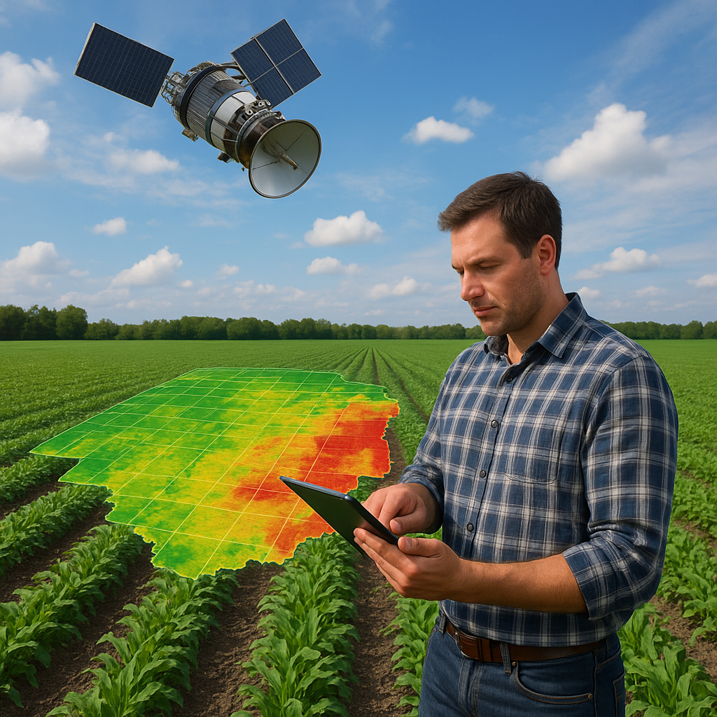
Monitoring crop health with vegetation indices
One of the most powerful applications of satellite data in agriculture is the assessment of crop health. This is often achieved through vegetation indices, mathematical combinations of light reflectance in different spectral bands. The most widely used is the Normalized Difference Vegetation Index (NDVI), which compares red and near‑infrared reflectance to indicate plant vigor.
Healthy plants absorb most red light for photosynthesis and reflect more near‑infrared light, leading to higher NDVI values. Stressed or sparse vegetation reflects more red light and less near‑infrared, resulting in lower index values. By mapping NDVI across a field, farmers can quickly identify areas of poor growth, nutrient deficiency or pest damage long before they become visible to the naked eye.
Beyond NDVI, other indices provide even more detailed insights. Some focus on chlorophyll content, others on water stress or biomass. These metrics help agronomists design targeted interventions, such as optimized fertilizer application or focused scouting, reducing costs and environmental impact while improving overall productivity.
Supporting precision agriculture and variable rate application
Precision agriculture seeks to manage within‑field variability rather than treating entire fields uniformly. Satellite data is a cornerstone of this approach because it reveals spatial patterns that traditional methods often miss. Differences in soil fertility, moisture, compaction and historical management practices all influence crop performance, and these variations appear clearly on satellite‑derived maps.
Using these maps, farmers can create management zones and variable rate prescriptions for seeding, fertilization and crop protection products. High‑potential areas may receive more inputs to maximize yield, while poorer zones are managed more conservatively to avoid waste. This strategy increases input efficiency and profitability, while lowering the risk of nutrient leaching and chemical runoff.
Modern machinery equipped with GPS and variable rate controllers can automatically adjust application rates according to georeferenced satellite maps. This seamless integration between space‑based observations and on‑ground equipment is a key element in the evolution of truly precision and data‑driven agriculture.
Soil moisture, irrigation management and water efficiency
Water is a critical resource in agriculture, and its efficient use is becoming more urgent due to climate variability and growing competition from other sectors. Satellite data supports better irrigation management by providing information on soil moisture, evapotranspiration and crop water status.
Some satellites are equipped with sensors that can estimate surface soil moisture directly, while others allow the derivation of water‑related indices from thermal and optical bands. By comparing these indicators over time, farmers can identify zones that are over‑ or under‑irrigated and adjust schedules accordingly. This helps save water, energy and labor while maintaining or improving yields.
In large irrigation schemes, satellite‑based monitoring also helps authorities and water managers assess compliance with water allocation policies, detect leaks in canals and evaluate the performance of infrastructure. Ultimately, space‑derived data contributes to more sustainable and equitable water distribution across entire regions.
Yield forecasting and production estimation
Accurate yield forecasts are valuable for farmers, traders, insurers and policy makers. Satellite data enables early and repeated estimations of crop production at field, regional and national scales. By analyzing vegetation indices, biomass proxies and phenological stages, models can predict final yields weeks or even months before harvest.
At the field level, farmers can use these forecasts to plan harvest logistics, storage capacity and marketing strategies. For agribusinesses and cooperatives, satellite‑based yield estimation supports supply chain planning and contract management. On a broader scale, governments and organizations can monitor food security conditions, anticipate shortages and coordinate responses.
The reliability of yield forecasts improves when satellite data is combined with historical yield records, weather information and detailed crop models. This integrated approach reduces uncertainty and allows more informed decisions across the agri‑food value chain.
Detecting pests, diseases and abiotic stress
Pests, diseases and abiotic stresses such as drought, heat or salinity can cause severe yield losses. Early detection is crucial to limit damage and reduce reliance on blanket chemical treatments. Satellite imagery helps by highlighting abnormal patterns in canopy development and color that may indicate emerging problems.
For example, a sudden drop in vegetation index values in a specific part of the field may suggest localized pest infestation or nutrient deficiency. Field scouts can then focus their inspections on these zones, saving time and ensuring quicker responses. In some cases, time‑series analysis of satellite data can reveal subtle changes in growth trajectories that are associated with specific stresses.
When integrated with ground observations and sensor networks, satellite monitoring forms part of an advanced warning system. This approach supports more rational, targeted crop protection strategies, reducing costs and environmental risks while preserving beneficial organisms and biodiversity.
Field boundary mapping and farm inventory
Reliable information on field boundaries and land use is essential for farm management, subsidy administration and environmental monitoring. Satellite images provide an up‑to‑date, objective basis for mapping fields, identifying crop types and assessing land cover changes over time.
Farmers and advisors can use this information to maintain accurate farm records, plan rotations and document compliance with regulations. Authorities, in turn, can verify declarations, monitor the implementation of agri‑environmental schemes and detect unauthorized land conversion. Consistent, high‑resolution mapping also supports land consolidation programmes and infrastructure planning.
For larger enterprises, having a comprehensive, satellite‑based inventory of all managed fields simplifies coordination of operations, benchmarking between sites and long‑term strategic planning.
Environmental monitoring and sustainability
Modern agriculture is not only about maximizing yields; it is also about protecting ecosystems and responding to climate change. Satellite data plays a central role in measuring and improving the environmental performance of farming systems. It helps track soil cover, crop rotations, residue management and the presence of natural habitats such as hedgerows and buffer strips.
By assessing biomass and land cover over large areas, satellites contribute to estimates of carbon sequestration and greenhouse gas emissions from agriculture. This information is important for climate policies, carbon credit schemes and sustainability reporting. Farmers who adopt climate‑smart practices can use satellite‑derived evidence to demonstrate their contributions and access new market opportunities.
Moreover, long‑term satellite archives provide an invaluable record of land use change, deforestation, wetland loss and urban expansion. This historical perspective supports better land‑use planning and helps identify pathways toward more sustainable and resilient landscapes.
Weather, climate and risk management
Weather variability is one of the largest sources of uncertainty in agriculture. While satellites do not replace ground weather stations, they enhance meteorological models with observations of clouds, temperature, humidity and radiation over vast areas. This improves short‑ and medium‑range forecasts that are crucial for timing field operations.
For risk management, satellite data contributes to the design and implementation of index‑based insurance products. Instead of measuring individual farm losses, insurers use indicators such as rainfall deficits, vegetation indices or temperature extremes over predefined zones. When these indices exceed agreed thresholds, payouts are triggered automatically.
This system lowers transaction costs, reduces disputes and expands access to insurance, especially in regions where traditional loss assessment is impractical. It also encourages farmers to invest in productivity‑enhancing practices, knowing that they have some protection against climate‑related shocks.
Integration with farm management systems
The true value of satellite data emerges when it is integrated into broader farm management systems. Modern platforms link satellite imagery with yield maps, soil tests, machinery telemetry and financial records. This creates a comprehensive view of the farming operation and enables more informed, holistic decisions.
Decision‑support tools can automatically analyze incoming satellite data, highlight anomalies, propose interventions and even generate variable rate prescriptions. Farmers receive clear, intuitive maps and alerts instead of raw technical data. As a result, the barrier to adopting advanced technologies is reduced, even for users without specialist remote sensing expertise.
Over time, these systems accumulate detailed historical archives for each field, supporting benchmarking, experimentation and continuous improvement. They also facilitate communication between farmers, agronomists, contractors and financial institutions, all of whom benefit from a shared, objective information base.
Benefits, limitations and data quality considerations
Satellite data offers a range of advantages in agriculture. It covers large areas consistently, provides regular updates and is often more affordable than extensive ground surveys. It also offers a unique, objective perspective that is not influenced by human bias. For many applications, this represents a major improvement over traditional methods.
However, users must also be aware of limitations. Optical imagery is affected by clouds, atmospheric conditions and low sun angles. Spatial resolution may not capture very small fields or fine‑scale variability. In addition, transforming raw images into useful agronomic information requires appropriate processing, calibration and validation.
Ensuring data quality involves comparing satellite‑derived indicators with field measurements and adjusting models accordingly. It is also important to select suitable satellites and products for each specific use case, balancing resolution, revisiting frequency, cost and coverage. Combining different data sources, including drones, ground sensors and farmer observations, often delivers the most reliable results.
Future trends and innovations
The role of satellite data in agriculture will continue to grow as technology evolves. Higher‑resolution sensors, more frequent revisit times and improved spectral capabilities will provide richer, more detailed information. Advances in machine learning and cloud computing will allow faster, more accurate analysis of massive datasets.
New applications are emerging, such as automatic crop type classification, real‑time detection of field operations and refined estimates of soil properties. Small satellites and commercial constellations are increasing competition and innovation, while open data policies from public agencies remain a crucial foundation for many services.
In the long term, the integration of satellite data with robotics, autonomous machinery and advanced decision‑support systems will help create highly efficient, low‑impact farming systems. These innovations will be essential for meeting global food demand while respecting environmental limits and adapting to climate change.
Conclusion: satellites as a strategic tool for modern farming
Satellites have moved from being a niche scientific tool to a practical, everyday resource for agriculture. They provide continuous, objective insight into crop health, soil conditions, water use and environmental impacts. When translated into clear, field‑level recommendations, this information enables more precise management, higher productivity and reduced resource use.
For farmers, agronomists and policy makers, understanding how to interpret and apply satellite data is becoming a key skill. By collaborating with technology providers and integrating satellite‑based services into farm management, the agricultural sector can become more resilient, efficient and environmentally responsible. In this way, space technology is not distant or abstract; it is firmly rooted in the soil, shaping the fields that feed the world.